


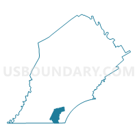
FRANKLIN TWP Voting District, Chester County, Pennsylvania
About
Outline

Summary
| Unique Area Identifier | 658426 |
| Name | FRANKLIN TWP Voting District |
| County | Chester County |
| State | Pennsylvania |
| Area (square miles) | 13.14 |
| Land Area (square miles) | 13.06 |
| Water Area (square miles) | 0.08 |
| % of Land Area | 99.37 |
| % of Water Area | 0.63 |
| Latitude of the Internal Point | 39.76310580 |
| Longtitude of the Internal Point | -75.82649700 |
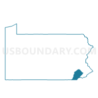
Maps

Graphs
Select a template below for downloading or customizing gragh for FRANKLIN TWP Voting District, Chester County, Pennsylvania


Neighbors
Neighoring Voting District (by Name) Neighboring Voting District on the Map
- Cecil Precinct 04-001, Cecil County, MD
- ELK TWP Voting District, Chester County, PA
- LONDON BRITAIN TWP Voting District, Chester County, PA
- LONDON GROVE TWP VTD SOUTH, Chester County, PA
- NEW GARDEN TWP PCT SOUTH, Chester County, PA
- NEW LONDON TWP Voting District, Chester County, PA
Top 10 Neighboring County Subdivision (by Population) Neighboring County Subdivision on the Map
- New Garden township, Chester County, PA (11,984)
- District 4, Fair Hill, Cecil County, MD (8,847)
- London Grove township, Chester County, PA (7,475)
- New London township, Chester County, PA (5,631)
- Franklin township, Chester County, PA (4,352)
- London Britain township, Chester County, PA (3,139)
- Elk township, Chester County, PA (1,681)
Top 10 Neighboring Unified School District (by Population) Neighboring Unified School District on the Map
- Cecil County Public Schools, MD (101,108)
- Avon Grove School District, PA (30,080)
- Kennett Consolidated School District, PA (27,089)
- Oxford Area School District, PA (25,814)
Top 10 Neighboring State Legislative District Lower Chamber (by Population) Neighboring State Legislative District Lower Chamber on the Map
- State House District 13, PA (77,777)
- State House District 158, PA (68,769)
- State Legislative Subdistrict 34B, MD (46,394)
Top 10 Neighboring State Legislative District Upper Chamber (by Population) Neighboring State Legislative District Upper Chamber on the Map
Top 10 Neighboring 111th Congressional District (by Population) Neighboring 111th Congressional District on the Map
Top 10 Neighboring Census Tract (by Population) Neighboring Census Tract on the Map
- Census Tract 3117, Chester County, PA (8,740)
- Census Tract 3069, Chester County, PA (5,631)
- Census Tract 306.02, Cecil County, MD (4,792)
- Census Tract 3067, Chester County, PA (4,352)
- Census Tract 3065.01, Chester County, PA (4,153)
- Census Tract 306.01, Cecil County, MD (3,818)
- Census Tract 3066, Chester County, PA (3,139)
- Census Tract 3068, Chester County, PA (1,681)